Mongolia: In the Footsteps of Genghis Khan, Part 1: To the Almsgivers Castle and Return |
This collection of images is from my July, 2007, trip to Mongolia, as a participant in a 3-week study tour organized by the Graham School of the University of Chicago. It was led by Dr. John Woods, Professor of Iranian and Central Asian History, and of Near Eastern Languages & Civilizations in the University of Chicago. Professor Woods had been the principal historian of the Genghis Khan Expedition, and we visited the expedition's archaeological site during our time in Mongolia.
We used the Bayangol Hotel in Ulaanbaatar as a central base, and made excursions of several days each from there to other parts of Mongolia. This photo gallery covers our first excursion, to a number of locations connected with Genghis Khan and the history of the Mongol Empire, including the "Almsgivers Castle", which may even contain the grave of Genghis Khan. |
| |
 |
This is a panoramic view of Ulaanbaatar as seen from my hotel room window at the Bayangol Hotel. To my western eyes Ulaanbaatar is not a very attractive city, but it is growing as rapidly as economic conditions will allow, and the Mongols were nomadic herders, so they have no architectural traditions of their own for large permanent buildings other than palaces (which tended toward the Chinese style). The total population of Mongolia is estimated at 2.8 million, and half of them now live in Ulaanbaatar. The need for residential and commercial space has driven a building boom, and the result is a mixture of generic Soviet, Chinese and Western styles randomly juxtaposed. Some buildings are painfully unadorned; some others are absurdly pompous or garish; and the rest fall somewhere in between. Any bit of land left unpaved and un built upon is left to its own choice of dust and weeds; here and there a small flower garden might be found, but lawns are rarely seen except at the American Embassy and a few other locations defined by foreigners. |
| |
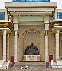 |
A huge statue of seated Genghis Khan is at the entrance to Parliament House, Ulaanbaatar. |
|
| |
|
"Chinggis Urguu", near Ulaanbaatar, is said to be a model of a 13th century Mongol Camp. |
|
|
| |
| We have a luncheon at "Chinggis Urguu" to meet some of the Genghis Khan Expedition members. Clockwise from left in this picture are Jeanne, Charlene, Michelle, Jerry, Tom, a Mongolian expedition member whose name I cannot recall, Prof. John Woods, Orgil, Prof. Bazarguur, Buju, and Pranjal. Orgil is a former Mongolian government official who handled logistics for both the expedition and our study tour. Prof. Bazarguur is a Mongolian historian who was part of the expedition, and Buju is our national guide. |
| |
|
In another fancy ger, this one just outside the Khan Bank in Ulaanbaatar, we meet with CEO Pete Morrow (center), to hear about Mongolia's economy and growth prospects. |
|
|
The top of the Khan Bank's ger has ventilation openings, a chimney stack and electric lights. |
|
|
|
| |
 |
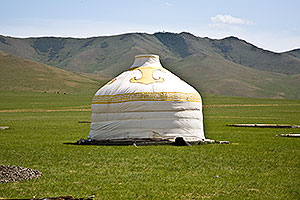
At a more utilitarian level, the ger is the traditional Mongol dwelling. Portable, sturdy and comfortable, it has a collapsible wooden frame and a felt cover. Flaps at the top and around the base can be opened or shut to control temperature and ventilation. The frame is erected first, and then the cover is wrapped around it (left). In a few hours the ger is up and ready for use. |
 |
|
| |
|
Mongolia does not have much paved highway. Outside of the Ulaanbaatar area almost all roads are like this one -- unimproved dirt tracks. When mud or deep gullies make the existing road unusable, vehicles simply go around the problem, creating a new lane. |
|
|
Traditional Mongol transportation is the horse, and by some accounts horses still outnumber humans in the country. Mongol children living in the countryside learn to ride practically at birth, and are frequently seen tending herds of livestock. And yes, the natives are quite friendly. |
|
|
|
| |
|
Not far to the east of Ulaanbaatar, a bit off of the road between Nalaykh and Baganuur is Tonyukuk, a group of 8th century Turkish Empire steles with runic inscriptions, providing the oldest known specimens of the Turkish language. These and other Turkic relics found in many parts of Mongolia remind us that long before the Mongols ruled the land it was part of the Turkish Empire. |
| |
|
This is a very typical sight in the grassy steppes of Mongolia: a nomadic or semi-nomadic family unit with a ger or two, perhaps a shed or rustic stable, and little else. Here a summer thunderstorm passes over, adding drama. |
|
|
Until recently log cabins would have been found only in the northern taiga forest regions; few logs could be obtained in the central steppes or southern desert. But it is now possible to bring in truckloads of logs (and colorful paint). |
|
|
|
| |
| This is Blue Lake of the Black Heart Mountain, found about 175 miles east and slightly north of Ulaanbaatar. At this spot in 1189 the 27-year old Temujin was first elected a Khan (ruler) by a khuriltai (council) of his family and neighboring Mongol tribes. |
| |
| Beside the Blue Lake is a monument and a series of informative markers, each explaining some facet of Genghis Khan's life. |
| |
| Comfortable accommodations and a glorious sunset make our visit very pleasant. |
| |
| Wide open spaces. We are now driving northeast from Blue Lake to the Genghis Khan Expedition Site at Öglögchiin Kherem. We stop to rest (below), and note that a few more trees are appearing in the landscape as we get further along. |
|
| |
|
| |
 |
| |
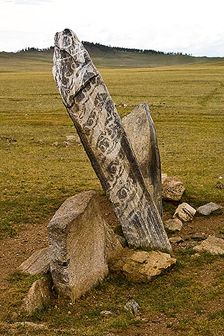 |
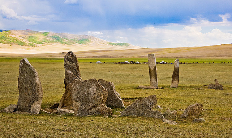
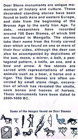
These are deer stones of neolithic origin, so-called because they are decorated with carved reindeer and other animals.
The explanation at right is provided by the Zanabazar Museum in Ulaanbaatar. |
 |
|
| |
| I believe that camels must be the most arrogant of all animals. Do not look a camel directly in the eye unless you are quite certain you want to know its opinion of you. |
| |
|
In the middle of nowhere, a directional sign! But road signs are rare; GPS is second only to local knowledge as the most effective means of navigation. |
|
|
This may be a case of motorcycle envy on the part of the rider, but to me the horse looks unimpressed. |
|
|
|
| |
|
Another rest stop; another thunderstorm. Pranjal (seated) is talking to Buju. |
|
|
Thunderstorms make mud. One of our three 4x4's gets bogged down in it. Orgil, John and Hurlee strategize. |
|
|
|
| |
| Nearing our destination at the Genghis Khan Expedition Site we are rewarded with brilliant wild flowers. A recent helicopter crash caused a fire which burned much of the forest, making way for the fireweed. |
| |
| Finally, we reach the cabins serving the Genghis Khan Expedition site. Behind the cabins on the left is a portion of the Öglögchiin Kherem -- the "Almsgivers Wall", a 3.2km-long stone wall believed to date from the 8th Century. It surrounds a rocky hillside ("Almsgivers Castle") on which more than 60 graves have been found in minimal excavations to date. The enormous amount of labor required to build such a wall, as well as discovery of novel stone contrivances within it suggests that the site was very important, and radiocarbon dating confirms its continued use by the Mongols. Some theorize that this royal graveyard may include the final resting place of the great Khan, though this theory is hotly debated and by no means settled. |
| |
|
In the morning we enter the "Almsgivers Castle" site through a gate in the Öglögchiin Kherem. Next to the gate is a marker installed by the Genghis Khan Expedition. The expedition had an exclusive permit from the government of Mongolia to map, study, and excavate at this site. The main objective was to discover if the site contained the graves of Genghis Khan or other Mongolian royalty of his period. Although this was not conclusively established before the Expedition's budget ran out, there were many other noteworthy discoveries. Additional information can be found at http://www.sciencedaily.com/releases/2001/08/010818004646.htm. |
| |
|
We examine a number of the excavations, most of which have been filled in again after study. One has a protective cover (right), allowing further study to continue. John Woods (in beige clothing, left) shows us around the site and recounts the expedition's history and discoveries for us. |
| |
|
This is a map of the Öglögchiin Kherem. The tear-shaped area enclosed is on a steep hillside; the top is at a much higher elevation than the bottom. Our entrance was through the gate and road seen at lower right, and most of the excavations we have looked at are near the slanted trail, lower center. |
|
|
Later that evening Michelle and I explore the upper part of the enclosure. We are driven to a spot as high up on the back side of the hill as the 4x4 can safely get us to. From there we hike to the uppermost part of the wall, seen here. Note the height (about 10') and precision of the wall's construction. No mortar was used, yet much of the wall seems to be fully intact after 12 centuries. After climbing over the wall we hike down through the quiet cemetery, past the locations examined earlier, and back to the expedition camp. |
|
|
|
| |
|
Another view of the upper wall (this time from inside the enclosure), and a view of the valley from there. The roofs of the expedition site cabins are just barely visible through the trees at center right. |
| |
| |
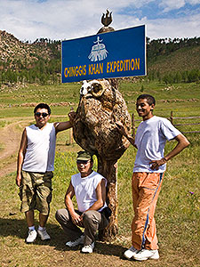
Some of the folks who work hard and serve us well, posing at the expedition site sign. Leftmost is 4x4 driver Miggy, and in the center is another driver, Hurlee. On the right is our national guide Buju. |
 |
|
| |
|
Further northeast of the Genghis Khan Expedition site is the village of Binder, located at the confluence of the Khurkh and Onon Rivers. On the way there we admire another deer stone, left. Just outside Binder is a marker erected by the expedition (center photo); it marks and commemorates the spot where Temujin was elected Genghis Khan (oceanic ruler) by an estimated 100,000 Mongols in the year 1206. Not to be outdone by a foreign-led expedition, a Mongolian Government official subsequently had a grander marker installed nearby (right). |
| |
|
This is the village gate of Binder (population about 5,000). |
| |
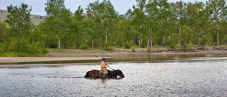
| And this is the Onon River, which flows gently toward the northeast from here. Although the exact place of Temujin's birth is disputed, it is believed that it was somewhere along this river, and the environs of the Onon River figure repeatedly in his history and in the history of the Mongol Empire. The modern Mongolian family at left may be picnicking at the same spot where Genghis Khan had lunch eight centuries ago. Here the Onon River is shallow and can be easily forded. |
 |
| |
| Leaving Binder, we stop at Rashaan Khad, a prominent rock bearing a great many carved inscriptions in Orkhon, Hidan, Arabic-Persian, Chinese, Tibetan and Mongolian languages. John examines the inscriptions, which include what appears to be a Mongol warrior on horseback (below right). There is also modern graffiti, and carvings of tribal seals resembling cattle brands, below. |
|
| |
| This explanation is provided by the Zanabazar Museum in Ulaanbaatar. |
| |
| Nearby is Binder Ovoo, a stone monument said to have been worshipped with offerings by Mongols since the time of Genghis Khan. The ovoo does appear to have been rebuilt much more recently. We are not sure what the hollow concrete things are for. |
| |
|
On our way south from Binder to Delgerkhaan we visit a Mongol family at their camp, which consists of three gers, a shed, a few dogs, and a great many horses. The ger we are invited into seems to be primarily the realm of the grand papa and children. We are entertained with conversation (a bit strained in translation) and snacks, including the ubiquitous fermented mares milk. Yummy. |
|
| |
| Whatever this family lacks in other comforts they make up for in horses. All of these are kept a short distance from the gers. Some are tethered to a raised wire (above) to prevent overeating of grass, because they will be raced in the upcoming Naadam Festival. |
|
| |
| Orgil inspects a road bridge. Conclusion: the bridge is not to be trusted. We go a bit downstream and ford the creek. |
| |
|
Our overnight stop is at the Khödöö Aral Ger Camp at Delgerkhaan, fairly typical of ger camps for tourists in Mongolia. There is a central building with showers and toilets, a large central dining ger, and a number of smaller guest gers. I share a ger with Tom (seated) and Pranjal (reclining), and everything is nice and comfy, except that a staff person comes in and lights a fire (to dispel dampness) even though the ger is plenty warm enough. The fuel is ... well let's just say that it is something plentiful around horses. While Tom and I are photographers on this trip, Pranjal creates a blog on his laptop as we travel. It can be found starting at http://pranjals.spaces.live.com/blog/cns!316EF137EE0F0DBE!1852.entry?_c=BlogPart. |
|
| |
| Upon leaving the next morning, we must perform the departure ritual with fermented mares milk, as Michelle does here. There is universal agreement amongst us that this fermented mares milk thing must be an acquired taste. |
| |
|
At Delgerkhaan a present day Mongol man stands at a monument commemorating the 750th anniversary of the writing of the Secret History of the Mongols. |
|
|
Outside of Delgerkhaan a present day Mongol boy takes a break from tending livestock and shows us how his rope is used. |
|
|
| |
|
Near Delgerkhaan, the Avarga Toson [Palace] was the first capital of the Mongol Empire; we look at a few visible remains of the palace and previous Japanese archaeological excavations. |
|
|
Outside the fenced remains of the Avarga Toson a pair of Bactrian camels wait patiently for something. This pair seems to approve of us. This is our last stop before returning to the Bayangol Hotel in Ulaanbaatar. |
|
|
| |
| This concludes the first part of our visit to Mongolia. For the second part, click here. |